Coquitlam looks to get ahead of rising waters with new flood plan
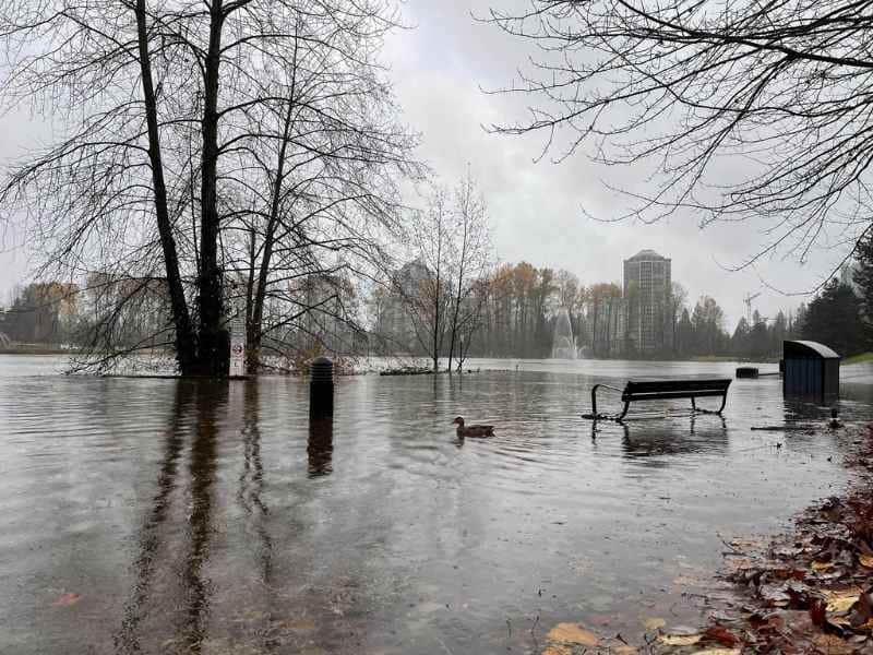
If the Coquitlam River jumps its banks, farmland and an industrial park are at risk of flooding.
To mitigate those risks, Coquitlam recently put out a call for a diking and flood protection analysis that would be implemented over several years with the municipality, Kwikwetlem, and Metro Vancouver working together, according to the city’s recently issued request for proposals.
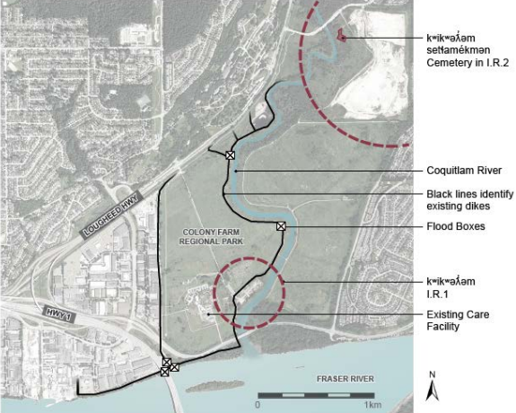
The area around ƛ̓éxətəm (tla-hut-um) Regional Park, formerly Colony Farm, and the Mayfair Industrial Park near United Boulevard are at particular risk of flooding, according to a 2017 assessment.
Local news that matters to you
No one covers the Tri-Cities like we do. But we need your help to keep our community journalism sustainable.

While there are linear dikes along the Coquitlam and Fraser rivers, as well as flood boxes and the Port Mann Pump Station, ƛ̓éxətəm isn’t protected by a dike and would face: “significant access and egress challenges in a flood,” according to the RFP.
Along with private landholders, the area is a mix of Kwikwetlem, municipal, provincial, Metro Vancouver and CP Rail land.
The dikes on the east side of Coquitlam River won’t be upgraded, largely because the area is protected by high ground, explained Coquitlam’s director of utilities Jonathan Helmus.
“At this point, all signs indicate that the east side is protected by high ground,” he said.
Some parkland is slightly more susceptible to flooding due to freshet but homes and businesses are all above the flood line, Helmus added.
The city and Kwikwetlem will also investigate the need for flood protection infrastructure on the north side of the Fraser, close to the Highway 1 crossing, he said.
The new flood plan would have to account for fish habitat, local archaeology, the kʷikʷəƛ ̓ əm setɬamékmən cemetery, as well as the proposed new dock/boom at the Fraser and Coquitlam River confluence.
Possible flood scenarios
The 2017 analysis simulated a dike breach at the east end of the Riverbend Drive subdivision near Port Coquitlam. In that scenario, water would flow northwest, overtopping Chine Drive and then streaming toward the area between Westwood Street and Firbrook Place.
“The flooding would reach the Scott Creek dike and inundate the lowland area up to Bouthot Court,” according to the analysis.
A breach at the north end of the ƛ̓éxətəm dike would mean water flowing west into the industrial park.
At the peak of the flood, most of the area between Lougheed Highway, Highway 1, the Mary Hill Bypass and the Lower Dike would become “inundated,” according to the analysis.
Giving infrastructure a raise
The analysis also recommended keeping the land near the dikes “free of impediments” to allow for raising.
The city frequently works with developers to raise the land around new construction, Helmus said, noting the Fraser Mills project at the bottom of King Edward Street involved raising the entire area to create a super dike.
Over the long-term, the analysis recommended raising the lower dike in the Coquitlam River and the DeBoville Slough south dike by 1.3 metres above the year 2100 profile.
The study noted sea levels were expected to rise one metre by the year 2100.
Author