Fremont Connector could link Coquitlam and Port Coquitlam by 2024
Cycling advocate warns of creating ‘bike lane to nowhere’
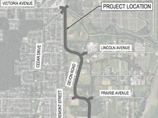
While we may still be a couple years from shovels in the ground, a preliminary design has been approved for a 4.7-kilometre road linking Port Coquitlam with northeast Coquitlam.
Beginning near the eastern edge of Burke Mountain at Victoria Avenue, the two-lane arterial would snake south toward Lougheed Highway and the Mary Hill Bypass via Lincoln Avenue, Devon Road, Prairie Avenue and Burns Road. The road, which roughly follows the contours of the Pitt River, is also slated to include a path for pedestrians and cyclists.
“Our residents and businesses in north Port Coquitlam will welcome a new north-south transportation alternative that will ease traffic in other parts the road network, including Coast Meridian, Prairie and Cedar Drive,” stated Port Coquitlam Mayor Brad West in a press release.
“This project will bring important road and active transportation improvements to support Metro Vancouver’s northeast sector. Residents and businesses on both sides of our border will benefit,” stated Coquitlam Mayor Richard Stewart.
Local news that matters to you
No one covers the Tri-Cities like we do. But we need your help to keep our community journalism sustainable.
Following public consultation and further design work over the next two years, construction is anticipated to begin in 2024/2025. Design renderings of the project are not yet available, according to Port Coquitlam staff.
Light the link
The new road should “greatly benefit people getting around by bike,” according to HUB Cycling Tri-Cities member Colin Fowler.
“This will become the first fully-protected north-south bike route in Port Coquitlam that isn’t a trail,” Fowler wrote to the Dispatch.
HUB has taken a keen interest in the project, largely due to the dangers of the Burns Road section as well as the Victoria and Cedar Drive intersection, according to Fowler.
“It’s a very harrowing intersection as people moving along the Traboulay Trail or dike trails have to cross fast-moving traffic on a blind corner. This makes it dangerous for all involved and we hope to work with the cities as well as funding partners to make the necessary changes,” he wrote.
To be a safe corridor for all cyclists, lighting is crucial, according to Fowler.
“A properly-lit multi-use path ensures people of all ages and comfort levels have a route that can be used all day and year-round,” he wrote.
More improvements needed
Given that cyclists are currently separated from Dominion Avenue traffic by a painted line, HUB will be push for safer infrastructure on routes that connect to Fremont, Fowler explained.
“The lack of safe infrastructure at the south terminus of the new Fremont Connector will seriously derail its potential to form a suitable grid of safe biking routes,” he wrote. “Such poor connections will reduce the effectiveness of the cycling accommodations on the new Fremont Connector, potentially reducing it to being a ‘bike lane to nowhere’ on the south end.”
Despite those concerns, Fowler explained that he was pleased to see the Fremont plans.
“Make no mistake, there’s still much to be desired throughout the Tri-Cities, but it’s good to see the cities continuing to embrace cycling and working to make it a safe and viable transportation option,” Fowler wrote.
Author