Port Coquitlam Mayor Bashes Proposed Electoral Riding As A ‘Creation Out Of Frankenstein’s Lab’
Map flap raises ire of mayor, MP
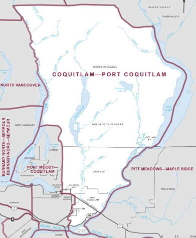
A proposed new electoral riding would leave Port Coquitlam both splintered and weakened, according to Mayor Brad West who led council in formally objecting to the idea Tuesday.
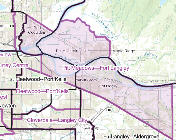
Dubbed Pitt Meadows—Fort Langley, the proposed riding squiggles around southwestern Port Coquitlam, swoops north near the Alouette River and continues east before dropping south in a straight line at the edge of Fort Langley.
The cities appear “thrown together,” according to West, who likened the riding to a: “creation out of Frankenstein’s lab.”
Local news that matters to you
No one covers the Tri-Cities like we do. But we need your help to keep our community journalism sustainable.
“It will really dilute our voice as a community,” West said, joining Maple Ridge’s mayor and council in opposing the riding.
Severing Port Coquitlam along the highway could lead to a feeling of separation, West said, noting the city has spent years spent trying to “overcome a sense of divide.”
“It doesn’t matter if you live on the north side or the south side, we’re all members of this community,” he said during Tuesday’s council meeting. “I’m also concerned that this boundary would heighten that sense of division.”
Depending on the location of the future MP’s office, Port Coquitlam residents in the Pitt Meadows—Fort Langley riding might also have trouble accessing service, according to West.
The map may also get a rocky reaction in Pitt Meadows, according to West.
“I have spoken to Mayor [Bill] Dingwall . . . he had the same reaction that most people have,” West said.
Following public hearings through summer and early fall, electoral boundaries commissions across the country are slated to submit a final report in December. MPs would have an opportunity to formally object to the new electoral maps in early 2023.
While uncommon, it is not unprecedented for a late-in-the-day change to the map following objections, West said.
Coquitlam-Port Coquitlam MP Ron McKinnon has also opposed the new riding.
“The good news is that British Columbia gained one additional seat in the House of Commons,” he wrote in a recently letter to Port Coquitlam council. “However, the bad news is that the Commission recommends that Port Coquitlam be severed into two constituencies.”
McKinnon promised to “vigorously oppose” the proposal.
The process
While commissions are charged with considering the input of all Canadians including elected officials, the commissions function as independent bodies and make all final decisions on where the borders will be drawn.
Electoral boundaries are reworked every 10 years following completion of the decennial census.
Canada is set to add four seats in the next federal election, with one of those extra seats going to British Columbia.
The extra seat would give B.C. 12.68 percent of provincial seats, up from the previous total of 12.54 percent. (Territories such as Nunavut and Yukon are treated separately).
New maps are scheduled to come into effect April 1, 2024 at the earliest.
Author