Atmospheric river pounds Tri-Cities as mudslide sweeps across Pipeline Road
An atmospheric river continued to drench the Tri-Cities on Thursday, triggering widespread closures, a mudslide-related power outage, and warnings from officials as river levels rise and the risk of flooding intensifies heading into Friday.
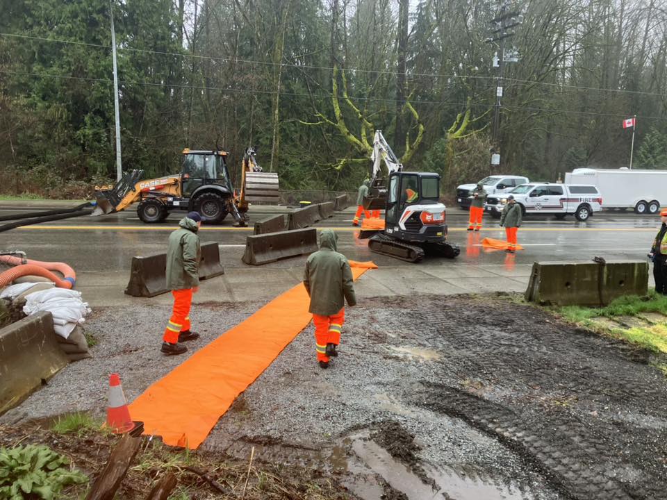
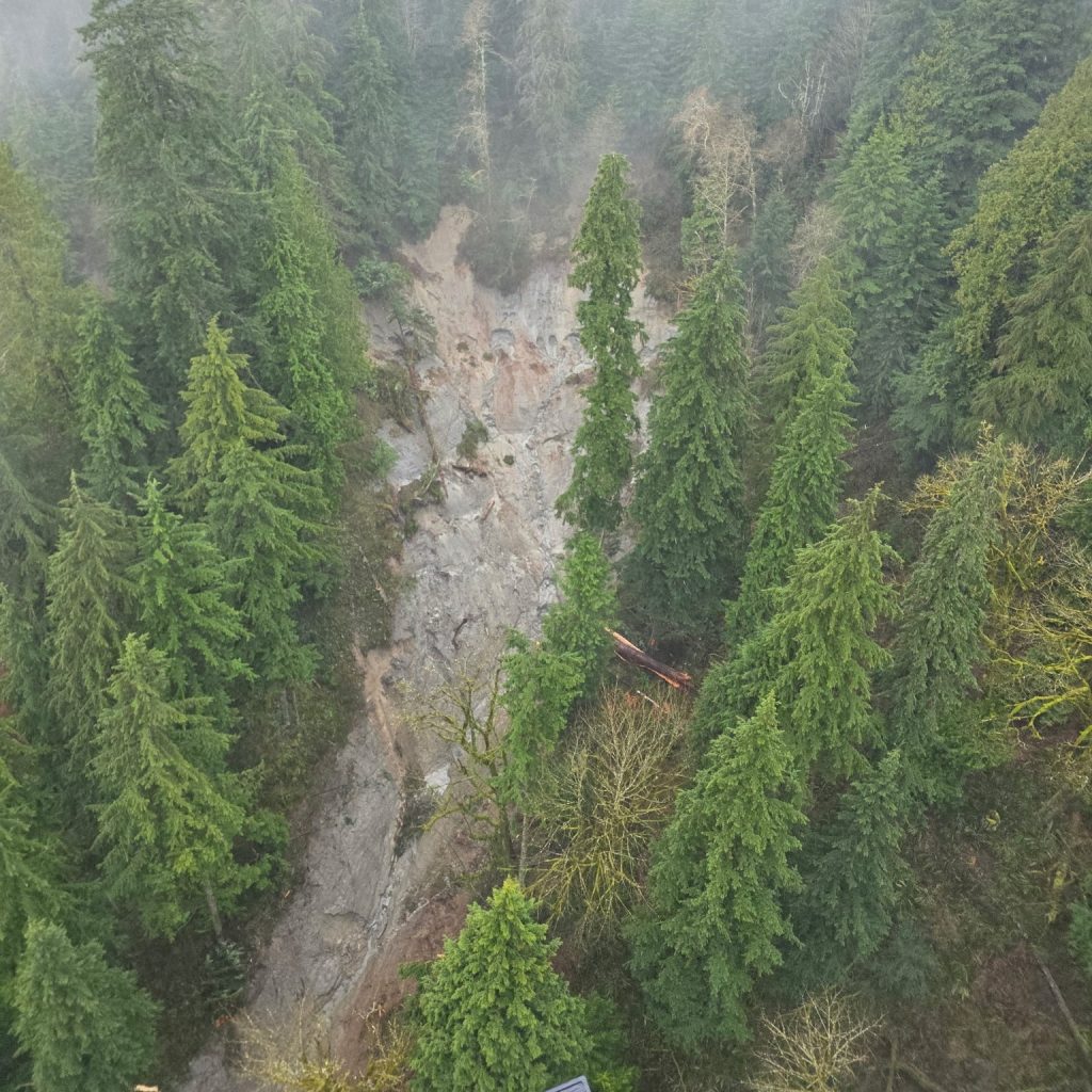
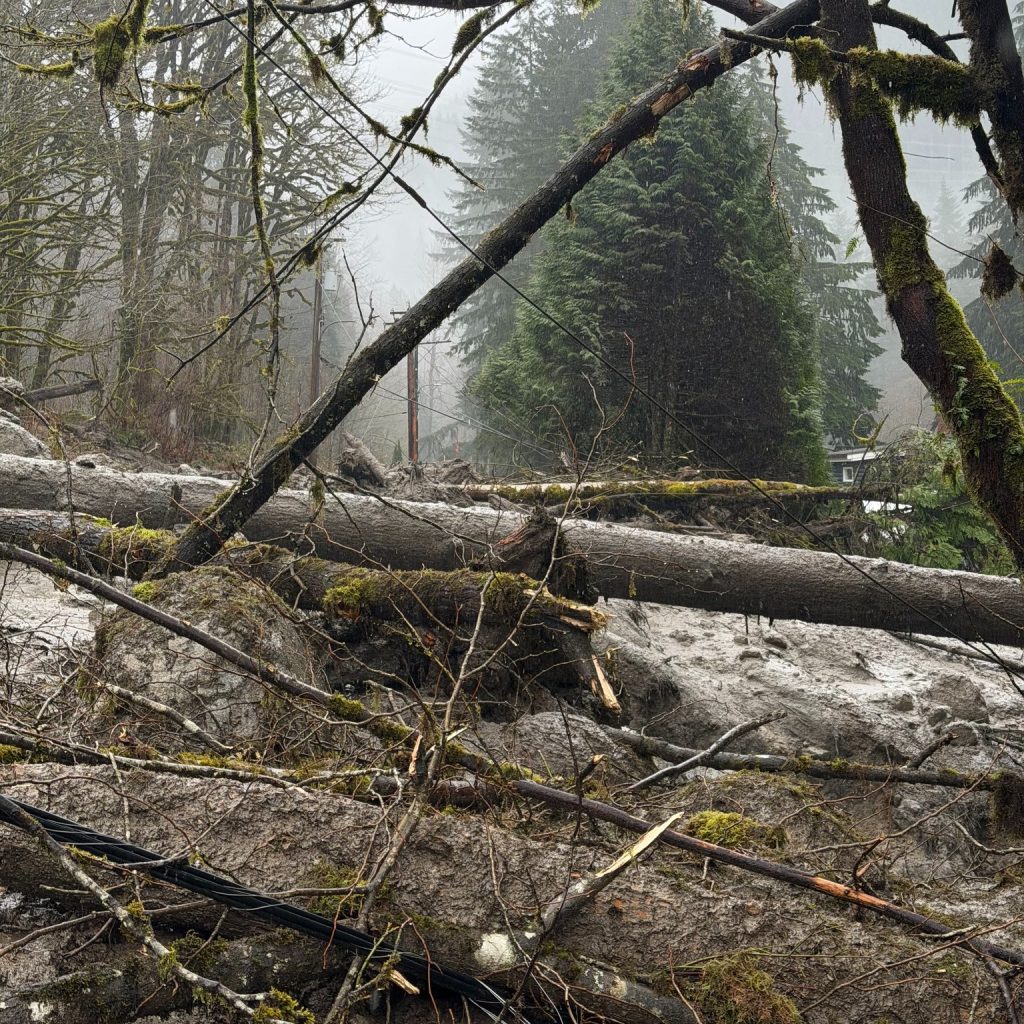
An early morning mudslide left several residents stranded on the north end of Pipeline Road.
Police, firefighters, and B.C. Hydro crews were dispatched to the 1900 block of Pipeline Road near Woodland Falls and just west of Pinecone Burke Provincial Park.
Local news that matters to you
No one covers the Tri-Cities like we do. But we need your help to keep our community journalism sustainable.
After arriving on scene shortly after 9 a.m., Coquitlam Search and Rescue volunteers used a helicopter long line to extract the residents as well as their pets from Pipeline.
The residents had been taken to safety by 2:45 p.m., according to a post from Coquitlam SAR.
Pipeline Road was closed to northbound traffic near the Coquitlam Water Treatment Plant and the public were asked to stay away from the area.
A geotechnical engineer was also dispatched to assess the situation.
Environment and Climate Change Canada has issued a high-impact “orange” rainfall warning for northeast Metro Vancouver, including Coquitlam, forecasting between 80 and 130 millimetres of rain by Friday.
Under the federal governments new rating system, orange warnings indicate “severe weather is likely to cause significant damage, disruption, or health impacts.”
The agency warns that prolonged heavy rainfall, combined with rapid snowmelt at higher elevations, could significantly amplify runoff into local waterways, increasing the likelihood of flooding, road washouts and landslides.
The storm is being driven by a multi-day atmospheric river that has stalled over the South Coast. With freezing levels hovering between 2,000 and 2,500 metres, fresh mountain snowpack is melting quickly and feeding already saturated river systems.
The heaviest rain is expected overnight Thursday into Friday morning, before tapering off later in the day as a cold front moves across the region.
Provincial forecasters say the cumulative effect of days of rainfall is compounding the risk.
The B.C. River Forecast Centre has upgraded much of the South Coast – including Metro Vancouver tributaries – to a flood watch, warning that river levels are rising rapidly and could spill over their banks in low-lying areas.
The agency noted that soils are already saturated, meaning rivers and streams are likely to respond more quickly and dramatically to additional rainfall, with elevated flows potentially lasting into the weekend.
Across the Tri-Cities, municipalities mobilized work crews and began shutting down vulnerable areas as conditions worsened.
In Coquitlam, city staff said they have been monitoring waterways and closing sections of parks and trails, including areas around Mundy Lake, Lafarge Lake and Booth Creek. Officials are urging residents to stay away from creeks and rivers, warning that fast-moving water and unstable banks pose serious safety risks.
In Port Coquitlam, crews worked through the night to maintain stormwater infrastructure as part of an ongoing flood response, according to the city’s social media account.
“Protecting residents and property is our priority. By proactively installing tiger dams along Coast Meridian, City crews are taking important steps to help reduce flood risk and support community safety,” said Mayor Brad West. “I want to thank our staff for their hard work, quick response and continued efforts on the ground.”
While river levels had dropped slightly Thursday morning, the city said staff remain deployed throughout the community, particularly along Coast Meridian Road where pumps and a temporary barrier system remain in place as a precaution.
Several roads, trails and recreational fields have been closed due to local flooding and the risk of bank instability, particularly near Gates Park. The city continues to operate sandbag stations for residents as both a rainfall warning and flood watch remain in effect.
The City of Port Moody also warned of hazardous conditions as heavy rainfall led to water pooling in low-lying areas and rising creek levels.
The city says saturated soils are increasing the likelihood of landslides and making trees more prone to falling, particularly in wooded areas. Residents are being asked to avoid flooded roadways and to prepare for potential disruptions, including power outages and traffic signal failures.
The storm has already caused infrastructure damage in Coquitlam, where a mudslide north of Pipeline Road early Thursday brought down power lines.
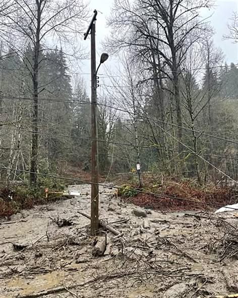
No injuries have been reported, according to the city, though four homes and two industrial properties have been cut off. The city is asking the public to avoid the area.
BC Hydro said approximately 5,000 customers were initially affected by the mudslide, with most service restored by the afternoon. However, a small number of customers remained without power as of Thursday due to unstable ground conditions that have delayed repair work. Crews are expected to complete restoration once it is safe to access the site.
Environment Canada is warning that travel conditions could deteriorate quickly as rainfall intensifies overnight, with some roads potentially becoming impassable.
Officials are urging drivers not to attempt to cross flooded areas, noting that water can conceal hazards or undermine road surfaces.
The current storm comes less than two years after a deadly atmospheric river in October 2024 which overwhelmed drainage systems across the Tri-Cities, flooding more than 100 properties and prompting Coquitlam staff to describe the event as a “once-in-200-year” storm.
In Coquitlam alone, record-breaking rainfall pushed infrastructure beyond its limits, while in Port Coquitlam, stormwater systems were unable to handle the volume, leading to localized flooding and property damage.
Two people died as a result of the 2024 storm event.
Authors